Northern Tier Day #40 Dickinson, ND to Wilbaux, MT
Northern Tier Day #40
June 29, 2019
Dickinson, ND to Wilbaux, MT 79 Miles
Ride Time 6:50
Tour Total 3187 Miles
I slept great last night at the Rodeway inn in Dickenson. The only problem was that I wasn’t used to being in Mountain Time and I woke up at 6am. I took my time getting ready. I finally lubed and cleaned my chain, and I noticed a slight wobble on my rear wheel. I always feel bad for the hotel person who cleans up after me. When I’m drying out camping equipment I leave behind leaves, sticks, dirt and bugs. I always tip the housecleaning staff.
It was surprisingly warm and humid outside. There was a huge weather system to the north that I’d been watching on my weather apps. I did a last minute readjustment and started the ride in my short-sleeve jersey and cycling shorts. I lathered up with sunscreen.
I saw banners for the Rough Riders Fair in Dickinson which I’d unfortunately be missing. There was a large foot race getting started at Dickinson State University and I had to detour around it to leave town. It was dark and cloudy, and it seemed like it could start raining at any moment. I was concerned that I could get hit by a large storm like yesterday morning. I took a risk and gave up my safe haven options as soon as I left town.
I wanted to get an early start and be on my way because of the wind. The forecast from last night called for strong headwinds from the northwest after Medora. This morning I was seeing tailwinds from the east from Dickinson to Medora. I could use those. West of Wilbaux there were definitely very strong headwinds on both of my weather apps. A roadside windsock showed the wind from the northeast. As long as it was from anywhere in the east I was happy.
All of my camping gear was dry. My clothes were clean, including my gloves. I was clean, shaven, and my ears were even swabbed. I stopped at an ATM and my coffers were once again full. I was ready for the west! It seemed likely that I wouldn’t see another town the size of Dickinson through to the coast.
I appreciate all the comments on Crazy Guy and Blogger. Thanks everyone! It means a lot.
I met east-bound cyclist Dave who was riding from Spokane to Minneapolis. He had done the Northern Tier back in 1998, before the oil boom when the route went through northern North Dakota. He was 77 years old and had been unsure whether he could do it again. He was on day number 18 and was doing just fine. He wasn’t camping but was traveling with gear in case he had to.
I passed a number of oil pumpjacks and some of them were working. It remained gray and cloudy but the threat of rain seemed to have diminished. I rode by two gruesome bunny roadkills. Heading towards Belfield old Highway 10 caught up with and paralleled Interstate 94. I would once again be riding stretches directly on the Interstate later in the day. Coming into Belfield I could feel the sun on my back, as it was trying to come out. I was drenched with sweat. This was the muggiest it had been on the trip.
I went to the Conoco Station where I bought an egg sandwich, a banana, a Starbucks Frappuccino, an orange juice, and a Gatorade. It was overcast again after my stop, and I continued on Old Highway 10 for another 5 miles, with I-94 immediately to my right. Cars and trucks were extremely dirty here. Their bottom halves were the color of brown mud.
At 135-1/2 Avenue Southwest I cut back onto I-94. The interstate overpass was closed for reconstruction, but it was a Saturday and work crews weren’t around. I made it across and continued onto the expressway.
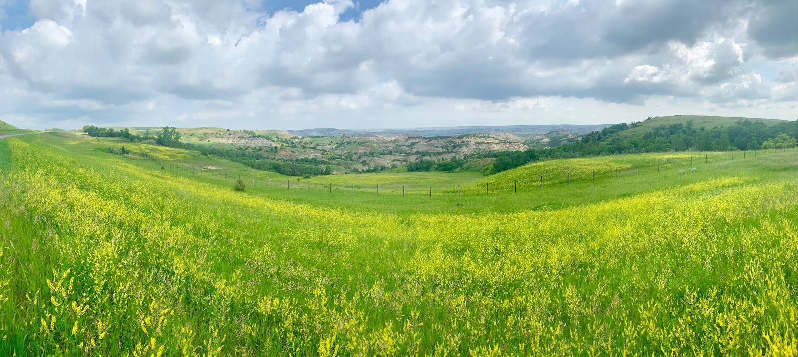
I entered the Theodore Roosevelt National Park. On this stretch of interstate I was riding on a nice 12 foot wide asphalt shoulder and the rumble strips were far over to the left near the white line. I could see eroded buttes and badlands to the north. It was broiling whenever the sun came out. The speed limit was 75 miles an hour. All of a sudden the badlands just opened up.
A semi truck drove by and blasted his horn. I gave him the finger and hope that he crashes into a telephone pole. About that same moment I saw a bull in a field across the expressway trying to hump a cow.
I stopped at the Painted Canyon Visitor Center and admired the Badland vistas to the north. There were numerous tourists, and people were curious about my trip. The next stretch had incredible panoramas.
Heading down a long hill on the Interstate into Medora, I noticed two eastbound cyclists on the other side of I-94. I set down my bike and ran across the median to meet them. Richard and Nancy were sporting bright yellow Boston or Bust jerseys. They were riding a modified Northern Tier from Seattle to Boston. They mentioned that they had seen two west-bounders ahead of me.
I exited I-94 on exit 27 to ride into Medora, which several people had urged me to visit. I was totally digging the colorful horizontal stripes through the eroded terrain. Medora has a population of 112 and boasts the North Dakota Cowboy Hall of Fame. My phone must not have been properly fastened because I went over a bump and it came flying off my handlebars. It slammed into the pavement and went tumbling across the shoulder. I quickly stopped to retrieve it. The screen is cracked but the phone is still working fine.
Medora is a tourist cowboy town. I went to Boots Bar and Tavern where I had a bison burger with a Beaver Creek Amber from Wilbaux. The little Missouri cuts through Medora. I enjoyed dipping down into the valley, but had to make it up on the other side. When I crossed over the Little Missouri Scenic River, I spotted kayakers enjoying the muddy water below. I found a little bike trail alongside the river which I rode back up to the Interstate. My wind app continued to indicate a headwind forecast out of Medora, which I was able to verify. I’d be climbing to 2,700 feet today.
At the I-94 junction I met Tom and Marilyn, from Coeur d'Alene, who have been riding the Lewis and Clark Trail in sections. This trip they were cycling the part from Great Falls to Dickinson. They told me not to drink the water in Circle or Jordan, and mentioned long stretches without services. There were a lot of bugs out today, and I had to keep my mouth shut. The wind really picked up, and I had a strong headwind. Back on I-94, I entered the Little Missouri National Grasslands.
I left the Interstate and was back on Old Highway 10 with a pair of train tracks to my left. I knew from the curly lines on my paper maps and my app elevation profiles that I would be doing a little bit of climbing. It was a lot cooler with the headwinds.
I was now seeing sage brush. I stopped and crumpled some in my fingers, and enjoyed the smell. The wind was from the northwest. Depending on which way the road turned, I either had a headwind or a crosswind. The adjacent train tracks indicated a mellow grade. A freight train full of coal passed me going east. Your days are numbered coal.
I climbed up out of the Little Missouri River Valley and away from the badlands back up onto the plateau. There was a very strong headwind and a cool mist. It was foggy up on the plateau and 3,130 foot Camel’s Hump Butte was a distant fuzzy silhouette. I could barely make it out. My headwind was ridiculous and I could only pedal 6 miles an hour.
I made my way around a large beautiful conical butte. I admired it from a distance, but when I got closer I noticed that someone had erected a cross on top, and in my opinion ruined it. It was foggy and I was unable to see my approach to Sentinelle Butte, population 56. When I arrived the gas station and services were closed.
Outside of town, I once again had grass to both sides of the road. There were no telephone poles or fences, and only the occasional silo or cattle far off on the horizon. I-94 was just to the north. The sun was trying to poke through, but I preferred that it stay hidden behind the clouds. The road was perfectly straight for 6 miles, and in the far distance I could make out Beach, population 1,019. I could see the water tower and grain elevator well before I got there.
I stopped at the Flying J Travel Plaza and purchased a Gatorade, mixed nuts, and a banana. The clerk was complaining about the humidity and said that it was very rare for these parts. It was my last stop in North Dakota, which I greatly enjoyed and thought was a beautiful state.
The last stretch to Wilbaux was on I-94. I had a nice 12 wide foot shoulder with rumble strips way over to the left near the white line. It was a smooth asphalt surface. I crossed over into Montana, state number 13. I met a young couple from Minneapolis who arrived at the border sign right after my nude photo shoot. I was delighted to take their photo with an old-school film camera.
It was another 8 miles to Wilbaux. The speed limit in Montana is 80 miles an hour and I was going 14. Approaching my destination I passed a freight train full of coal. It was a mile long and headed east. Wibaux is the gateway to Montana and proclaims to be a historical town.
I traveled through Montana last year on the TransAm and recognized the arrowhead highway signs, the white cross signs that mark highway fatalities, and the restrictions to prevent invasive species. I was staying at the Beaver Valley Haven RV park. I set up my tent, showered, and did laundry. I went to the Beaver Creek Brewery where I ordered the prime rib dinner with several Amber Ales.


Comments
Post a Comment