Northern Tier Day #47 Chester, MT to Cut Bank, MT
Northern Tier Day #47
July 6, 2019
Chester, MT to Cut Bank, MT 68 Miles
Ride Time 5:14
Tour Total 3689 Miles
I slept great last night at the Chester City Park in my tent out on the grass. It was long lush grass, and very comfortable. The downside was that there was ample condensation and dew in the morning. I rolled up a soaking wet tent that would need to be strapped to the top of my rear bag. I heard freight train horns throughout the night. The stars were brilliant when I got up in the middle of the night to use the bathroom.
This morning I went to the Liberty Quick Stop and got a Starbucks Frappuccino, an orange juice, and a banana. The clerk reminded me about the construction ahead and I saw an orange sign as I left town. The sky was mostly clear with a strong bright sun. The air was cool so I put on my leg-warmers and rain jacket. The wind was coming from the south and a little from the east giving me tailwind. I was riding 14 miles an hour. it perfectly flat except for the grass hills to the north. I was told that I’d be able to see the Rocky Mountains from Shelby. Cut Bank is the break between Northern Tier map sections three and two, and I’d be ending the day at 4,000 feet elevation.
A westbound freight train pulling tank cars passed me and I couldn’t get him to blow the horn. I rode by Tiber which wasn’t even listed on my map. It was basically just a grain elevator complex. The weather was warming up so I pulled over to remove my jacket. I still had on my sweater and jersey.
It was me, the Hi-Line, fields of wheat to both sides of the road, a railroad track, the Sweet Grass Hills to the north, and a big Montana sky. I pinched myself, because I was so lucky to be able to experience this. An eastbound freight train approached pulling stacks of containers, and I successfully convinced them to blow their horn. Small absurd victories add up to something. I could spot the grain elevator in Luthair from several miles out. There was no population listed on my map, and no services.
I mentioned this previously, but I wanted to bring it back up because I've seen so many of them. Montana erects small white crosses wherever there’s been a traffic fatality. I’ve passed dozens and dozens. Many were adorned with flowers and other mementoes.
I began sharing the shoulder with a bright yellow string that ran thousands of feet. It occurred to me that it probably had something to do with the construction up ahead. Sure enough a bright orange sign appeared on the horizon. ‘Road Work Next 9 Miles’. Ugh! I thought it was supposed to be 7. My hope was, it being Saturday, there would be no work in progress. I had heard that the west end had been paved, and that it wasn’t as bad as it had been a few weeks ago. Then I saw the orange barrels and a sign that said ‘End of Pavement’. The shoulder was still available for another 1000 feet, and then I was riding on hard packed gravel. It was bumpy, but it wasn't loose. I had to choose the smoothest path down the middle of the road, and was worried about motorized traffic.
I was cycling 18 miles an hour, and it wasn’t bad at all. I was so lucky to be doing this while no work was in progress, which could have been a nightmare. I was passed by several cars, pick-up trucks, and motorcycles. I was fortunate that it wasn’t dry and dusty. It got a little gravelly but it was never nearly as bad as that 10 mile gravel road in Iowa. After 4 miles I could see a brand new asphalt surface in the distance. I was keeping my fingers crossed that this would be the end of the construction. I passed a small cemetery right before Galata, no population listed. Asphalt returned to the westbound lane. Lucky me! East-bounders still had to ride on packed gravel. It was now smooth sailing, and I was pedaling 19 miles an hour.
Galata was the nerve center for the road construction crew. Construction vehicles and road equipment were stored there. The general store was open but I was planning a straight shot to Shelby. I crossed a small bridge and then asphalt returned to the eastbound lane. The white line and rumble strip hadn’t yet been laid down. I had a sharp drop down into the dirt to the right of the road, and didn’t want to get too close to the edge. After exactly 9 miles, the ‘End of Road Work’ sign appeared. That was not bad at all. Whew!
It had clouded up and the sun was no longer casting a shadow. Two miles out I could see the grain elevators from Devon, no population or services listed. There was a large weather system to the northwest with dark menacing clouds. I expected to pass to the south of it.
The train tracks returned to the side of the highway. I was surrounded by fields of wheat and a telephone line 100 feet to the left of the road. I was still admiring the Sweet Grass Hills to the north, and Dunkirk came into view several miles down the road. The Frontier Bar was closed. Dunkirk had no services, but there was a giant billboard advertising extensive services in Shelby just 10 miles ahead.
I saw a roadside information sign announcing that Glacier National Park was 99 miles ahead. Wow! That was exciting! I had no place to shower yesterday and I’m wearing the same clothes, socks, and underwear. I‘ve slipped below level one.
After Dunkirk the sun came out and I had a shadow. There were clouds to the north and the system was drawing air current, giving me good wind all morning. Midway between Dunkirk and Shelby I found myself on the Old Forts Trail. I passed a roadway sign and marker stating this had been part of the Whoop Up Trail, that emerged in the 1860s.
I passed a roadside history sign that informed me about the Baker Massacre, another tragic slaying of innocent Native Americans by vengeful racist ignorant American military forces. I could see the Shelby water towers from 4 miles out, with a wind farm that I had heard about situated behind it. Shelby had a population of 3,379.
I had a downhill into Shelby, which was an important railroad junction town. Here a north-south railroad intersected with the east-west line. It was also the junction of interstate 15 with the Hi-Line.There were train yards all over town. Many of the freight trains that I’ve been seeing get loaded or unloaded here. Shelby had an Amtrak station, and the town banner displayed an old fashioned locomotive against a wind farm.
I stopped at Subway where I had a foot-long tuna fish sandwich with potato chips and a raspberry lemonade. I stripped down to my cycling shorts and short-sleeve jersey, and lathered up with sunscreen. The sun had become strong and bright, and I crossed underneath Interstate 15. To my right were numerous sets of train tracks with different types of freight cars lined up sitting idle.
I ran into east-bounder Craig, from Cincinnati. He’d been on the road for two weeks starting in Astoria Oregon. I was the first long-distance touring cyclist he had met. He had started with a buddy who had developed back problems. His friend rented a car and was continuing east, playing leapfrog with Craig. His friend would drive to the destination and then pedal out 15 miles to meet Greg and they’d both cycle back into town. Craig was using state maps to navigate, and spent last night in Browning.
It was rolling ups and downs with grass and wheat to both sides of the road. I was gaining 800 feet elevation on the 20 mile stretch from Shelby to Cut Bank. The ginormous wind farm stretched for miles to the south and west, and I still didn’t see any mountains. There was noticeably more traffic on US Highway 2, as motorists were taking Interstate 15 to Highway 2 to get to Glacier National Park.
The shoulder was narrow and frustrating. Finally it got wider, with the rumble strip between the white line and myself. An eastbound freight train passed me, and I got them to blow the horn. There was a large ridge with mud bluffs to the west and northwest. Several miles to the northwest I could make out another large wind farm.
I could spot Etheridge from a few miles out. The grain elevator was small, and no population was listed on my map. There was a tiny post office, but the town had no services. From here it was 11 miles to my destination.
Another eastbound freight train passed me but at this point the tracks were a quarter-mile to the north. The highway eventually merged with the railroad tracks again and a westbound freight train approached. I got them to blow the whistle. There was a large weather system to the west and another to the south. The wind was still out of the south and slightly to my back. 7 miles out of Cut Bank I entered Glacier County. The roadside smelled sweet from the wildflowers.
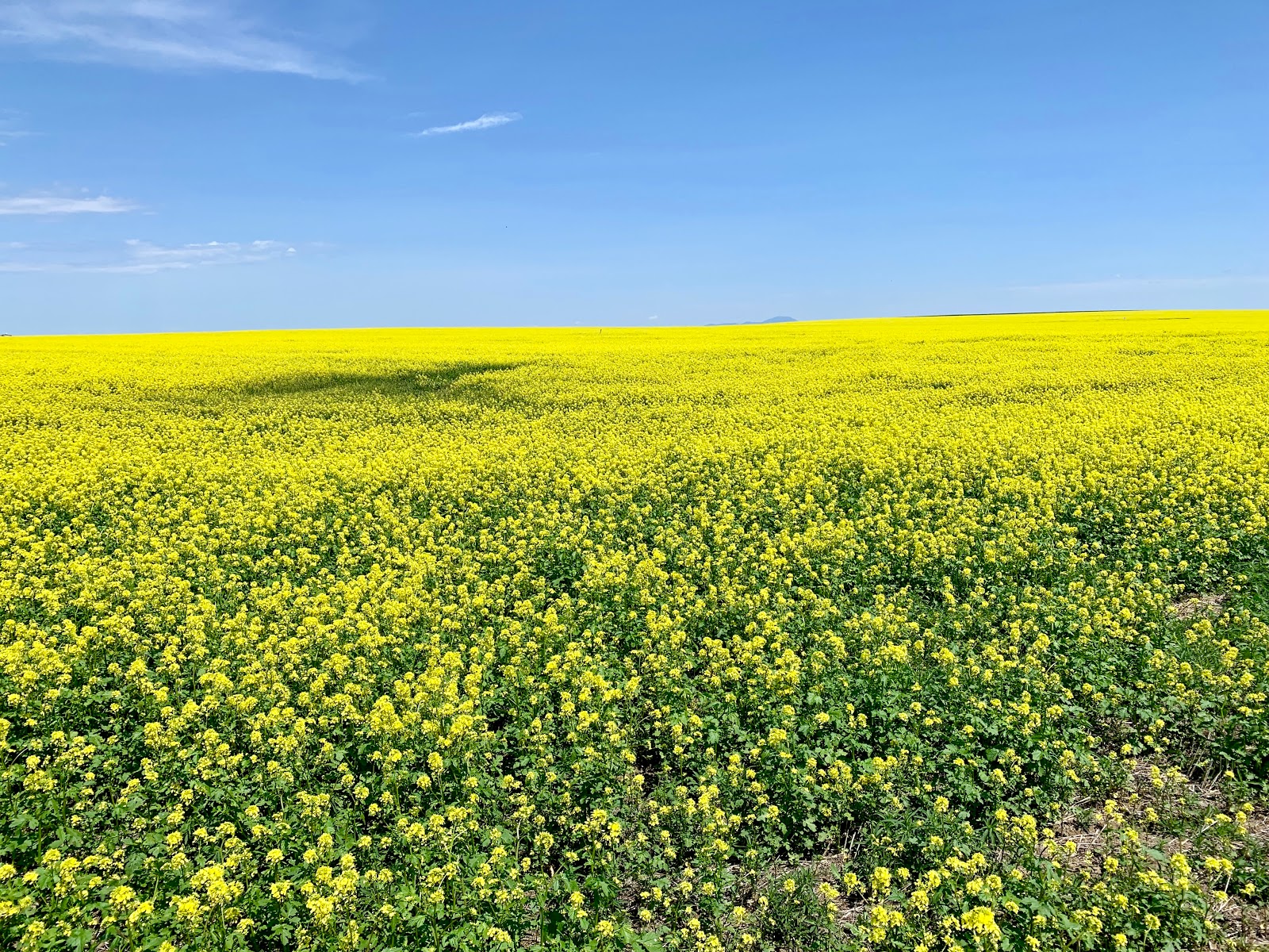
A few miles out from Cut Bank I could definitely see the mountains. They were huge, but still far in the distance. I passed a large yellow field of either mustard or canola flowers, and stopped to take pictures. I could now see the grain elevators in Cut Bank. An eastbound freight train passed and I got him to blow the whistle.
Cut Bank is served by Amtrak’s Empire Builder long-distance train on its route from Chicago to Seattle. There's one eastbound and one westbound train per day. I stopped and took my photo in front of the large Penguin. Because of the weather patterns up against the mountain range, Cut Bank is often the coldest town in the lower 48 states. I stopped at the Cut Bank Brewery and enjoyed several Penguin Piss Ales. Tomorrow when I leave Cut Bank, I’ll be saying goodbye to the Hi-Line and to Highway 2. The next chapter begins.


Hi. Do you know any of these bikers? https://www.inforum.com/lifestyle/health/3404545-Bicyclists-riding-coast-to-coast-volunteer-time-while-resting-in-Fargo KFHP from WFMU
ReplyDelete