Northern Tier Day #49 Cardston, AB to St. Mary, MT
Northern Tier Day #49
July 8, 2019
Cardston, AB to St. Mary, MT 74 Miles
Ride Time 6:27
Tour Total 3841 Miles
I slept well last night at the Lee Creek Campground in Cardston. I got my tent set up right before the thunderstorm struck. I laid inside on my Thermorest with a crippling stomach ache. Was it my poor diet yesterday and the day before - three Subway meals in a row? Was it the 2-1/2 gallons of lemonade that I guzzled when I got to Cardston? I think not.
My prognosis was that, after a 75 mile day, I was denied my daily beer staple. F Mormans. How dare they impose their religious beliefs on others. Joseph Smith was a bipolar nut job (Nothing against people with bipolar disorder. There are treatments. Just don’t start a religion). Come on! Golden plates? Jesus appearing in North America alongside the natives? Hogwash! While we’re at it, F Mitt Romney! I demand my beer! At least there was WiFi at the campground. I was in such rough shape last night, I didn't use the shower.
Last night before I fell asleep I did some looking ahead at map section #2, and tried to plan out Washington State. I’ve certainly saved the best for last. After weeks and weeks of prairie, I deserve the best. The climbing would begin today. I would be ascending to 5,800 feet elevation on the second and third passes. My total climbing for the day would be 4,938 feet.
In the morning I folded up my wet tent and packed up. It was a nice campground. I stopped at the On The Run Fast Gas Plus station where I had a Starbucks Frappuccino, an orange juice, and a pack of Audreys Patisserie Mini Donuts. I asked the clerk if they had Canadian flags but all they had were Canadian flip-flops.
Being abroad, I was able to sympathize with the French cyclist couple I had met in Indiana, who didn’t have internet service. I realized how much I depended on it. I went to the library last night in search of WiFi and I couldn’t get it from outside the building. I found a nearby source where I was able to poach WiFi to upload my journal updates and social media. Service was spotty at the campground. Riding through Canada I couldn’t google and use social media like I’m accustomed.
Cardston was definitely cleaner and nicer than any of the towns I had visited along the Hi-Line. If only it had beer and decent food. I started the day in cold weather gear, including my winter gloves. The locals were all in T-shirts. That said, they were driving around in motor vehicles. The air outside was crisp.
I took a left heading west on highway 5 and noticed the impressive Cardston Temple complex on a hill to the southwest. The incredible blue sky was crystal clear. I was going to have a beautiful day today with sun shining on the dramatic mountains.
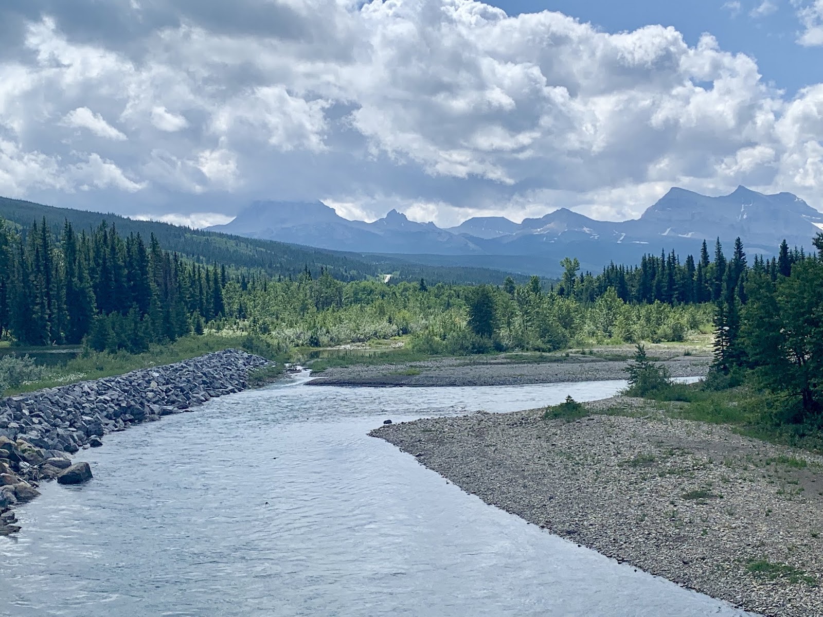
My detour into Canada was my transition from the prairie to the mountains. I began the morning in the prairie, and had mountains ahead of me. I was making a large hook around Old Chief Mountain and would travel south east into Glacier National Park. I could already tell it was going to be amazing!
Alberta Highway 5 had a really nice 2.5m wide shoulder with a 1m wide rumble strip. I had a smooth 1.5 m asphalt surface to ride on. I could now see the staircase on the west side of Old Chief Mountain that Don had mentioned yesterday. This was where he and his friends had climbed. He had mentioned that the bluff was shale, and that they don’t let people up there anymore.
I stopped and removed my down vest, balaclava, and winter gloves. I was pretty sure that this was the second time I’d worn my winter gloves on the tour. They kept my fingers toasty, but it was impossible to use my phone. I had to keep taking off my right glove, which was a pain while I was riding, and difficult to put back on.
The first town I passed was Weston, listed on my map as Leavitt. The panorama above town was off the hook. By coincidence Nina Simone came through on my EarPods singing a gospel rendition of‘My Sweet Lord’. Such indescribable beauty all around! By 8:15am small clouds were already starting to appear over the mountains.
I didn’t shower last night because of my stomach ache, nor did I do laundry. I was wearing the same clothing as yesterday. This is the part of the trip where I could veer away from level one.
I think I’ve discovered the source and incubator of all of those crazy weather systems I’d been dealing with in the prairie. There’s a bowl right where the tall mountains meet the plains and the clouds rise from and congregate there. I could no longer see Old Chief Mountain, as it became obscured by clouds.
I could spot Mountain View, Population 80, from 2 km out. I saw a church, houses, and trees against a magnificent panorama of incredible mountains. I stopped at the Bear Country Store where I ordered 2 egg sandwiches, 2 waffles, and 2 orange juices. It was a very friendly Morman staff. I asked about the Cardston Temple and he confirmed that it was a big important center. He explained to me that Brigham Young had a three point survival strategy; Utah, Cardston, and Mexico. He reminded me that Mitt Romney was from the Mexican contingent.
Back out on highway 5, I learned I was on the Alberta Cowboy Trail. I cruised down into the valley across the emerald colored Belly River. I was toasty on the uphill and cold on the way down. By 10:30am there were thick puffy clouds gathering around Old Chief Mountain. I passed two separate roadkill deer, a young buck and a doe.
This out-of-the-way loop into Canada was so worth it! The views were extraordinary, as I circled around and down it to Glacier. I took a left on highway 6 and headed south back towards the US border. This was the intersection with the ACA Great Parks North Route Section 2.
I entered Watertown Lake National Park. There were beautiful panoramas as I hooked back around towards Old Chief Mountain. The roadside was filled with wildflowers, including thousands of daisies. The next thing I knew, I was surrounded by trees, wildflowers, and I was in the mountains. The climb was heating me up so I pulled over and removed my leg-warmers and sweater, and I lathered myself with sunscreen.
The uphill was over a mile long and I was in my second lowest gear. Eight motorcycles passed me going north. There were tall straight pine trees to either side of the road and ahead of me. The sun was strong and hot.
I rode by a sign that read the ‘Sofa Fire of 1998’. I had seen charred tree trunks earlier in the climb. I was admiring Sofa Mountain to my right, and it was hard to keep my eyes on the road. I really needed to focus on the road because I had a steep shoulder to my right.
Two day cyclists passed me going north. I entered the Blood Timber Reserve and passed through the second barricade gate that shuts in the winter, when snow makes the road impassible.
I flew 33km an hour down the hill and it scared the hell out of me. I crossed over the North Fork of the Belly River which was crystal clear. A ranger from the Park Service was there collecting samples. I passed my third barricade and a sign prohibiting fire arms as I neared the US border.
I was passed by three more day cyclists heading north, flying down the hill that I was climbing. I got a text from the Tacoma crew, saying they were at Rising Sun Campground at Glacier and that there was still room for me at the hiker biker site. As I learned last year in the Grand Tetons, National Park Campgrounds can’t turn away a cyclist. They had to take me no matter what.
I passed the Welcome to Alberta sign and I knew I was close to the border. It was partly cloudy with some dark developments overhead. It was an uphill to the border, and I was banking on a downhill on the other side. I was doing 3.1km an hour on the uphill using my smallest front chain ring and the third from the largest ring on the cassette. The cool air and covered sun was perfect for the ascent.
I could see the American flag from .5km away, and then the border post came into view. On the Canadian side I spotted a group of touring cyclists. I stopped and talked with Eliana from the Overland organization. She and another guide were traveling from Missoula to Banff with 10 high school kids. She said that the kids were from all over the country. In Banff she would get a new group to take back down to Missoula. What a great job and a great experience for the kids!
At the US border I asked the customs agent if he’d seen other cyclists. He replied dozens, including a recent couple towing dog. I crossed into the US and found myself on the Chief Mountain International Peace Parkway. The views leading up to and around Chief Mountain were staggering. Chief mountain is 9,080 above sea level.
I met Mark, Cindy, and their dog Asta, from San Diego. They were touring from Jasper to Missoula, and then to Portland Oregon. Asta was being towed in a trailer behind Mark. They were in Waterton last night and were also headed to St. Mary’s this evening
As I was coming around Chief Mountain I could see the plains to the east, where I had been for weeks. They looked flat and distant like an ocean. Towering puffy clouds had developed over the Prairie. My fingers were crossed that I was now west of all that weather system BS.
I had a 3 foot wide shoulder with an asphalt surface that was a little ragged on the right. There were cracks and grass sprouting through. A southbound pick-up truck zoomed by me with two bicycles fastened to the rear. A park ranger approaching from the south motioned for him to slow down. Damn right! It was so cool to ride my bike around Old Chief Mountain.
The cows were grazing loose here. I saw one in the road and I stopped to take a photo. She got scared and scampered away. There were cow patties all over the road. Mark was tailing me and passed me on the climb. I’m a big guy and hills aren’t my strength. Both Scott and Steve G used to always pass me up hills on the TransAm. I rode around a big bend and then the expansive St. Mary’s River Valley opened up before me. I shot down the hill and took a right on Highway 89 into Babb. I passed a bunch of day cyclists and a support van. I am now in cycling country, that stretches from here to Missoula and all the way over to the coast.
The first town I encountered in the US was Babb, population 174. I could see buildings from half a mile away, against the enormous Lewis Range. I stopped at the Babb General Store where I adjusted my front fender that had been driving me crazy. I bought trail mix, Gatorade, and a bag of granola to replace my emergency stash. I met Steve, who had cycled the TransAm, Lewis and Clark, and Pacific Coast trail. He’s started a website to locate roadside picnic tables called getpicnick.com
Riding around Lower St. Mary’s Lake, I found myself wanting to stop every five seconds to take a photo. OMG! It was so beautiful, and there’s no way my iPhone could possibly capture it. I was having a hard time keeping my eyes on the road. Highway 89 had a lot of traffic, and there were a lot of campers, RV’s and tourists.
I was charged $20 to get into Glacier National Park. The ranger told me that St. Mary’s campground was full, and that I should pedal another 6 miles to hike/bike site 6 in Rising Sun. She also mentioned that there would be construction on the road tomorrow morning.
I had spotted a beer garden and a Mexican restaurant in St. Mary’s. With this in mind, I rode into St. Mary’s campground to inquire if anything was available. The ranger assigned me a hiker biker site to share. I set up my wet tent, showered, and did my laundry, which I hung on a line.
I rode back into town to Kipps beer garden where I ordered a huckleberry margarita, and several Lewis and Clark Huckleberry Hefe Weitzens. Next door at the Bad Frog Cantina Mexican Grill I ordered two shredded beef burritos, along with chips and salsa.
There was no internet or phone service in Saint Mary. I recharged my battery pack at the bar, and the bartender told me to go to the Glacier Park Visitors Center for WiFi.


Comments
Post a Comment