Northern Tier Day #55 Cusick, WA to Colville, WA
Northern Tier Day #55
July 14, 2019 Cusick, WA to Colville, WA 83 Miles
Ride Time 6:44
Tour Total 4321 Miles
Last night, as I do every evening, I worked on my report while enjoying the local beer. The problem last night was that I still wasn’t at my destination, so my GPS was still running and I didn’t have my final numbers. I couldn’t yet submit my report. I still had to ride to the next town where there was a campground and I would be spending the night. It was dark when I left the bar and I had to use my lights and navigate by app. I got to Cusick no problem, but I had a difficult time finding the campground in the dark. My headlight beam was pointed forward, so I could see highway signs but not what was parallel to the road. I used my ACA Bicycle Route Navigator app to pinpoint the campground location and encountered a locked gate at the Pend Oreille County Fairgrounds. I was tired and it was late, so I set up my tent right there in front of the gate in the grass. I used my headlamp to erect my tent, and locked my bike to the chain link fence. My report was submitted from inside my tent right before I went to sleep. I had forgotten to wake up my odometer when I left the bar, so my total mileage is now short 2.86 miles.
I slept only 100 feet from State Highway 20 but recall hearing no traffic or freight trains during the night. The noisy birds woke me up early, but I was able to roll over and slumber for another hour. The sun heated up my tent, and it was time to get up. There was a lot of condensation inside the fly. I tried to dry it out in the sun but got impatient and rolled it up damp. I went across the street to the Conoco station where I used the bathroom and washed my face. I haven’t had a shower or shave since Whitefish. I sat out front on the bench and enjoyed a Starbucks Frappuccino, an orange juice, and a banana. I had charged all of my devices last night at the bar.
The wind was out of the south which was a problem for me getting back to Usk. Things would presumably be fantastic after that. The plan was to get back to the route and then follow the river north for a map panel and a half to Ione. I would then head west, climbing 2,854 feet over a pass, and end up either in Colville or Kettle Falls, in preparation for Sherman Pass tomorrow.
I passed the Usk Bar & Grill and then rode back over the bridge to Le Clerc Road. I once again admired the wooden poles lined up in the river, and thought about the expansive lumbering of these mountains. I was once again in the Kalispell Indian reservation, and was heading north on Le Clerc Road with a tail wind. It was a cloudy day, and I was wearing my cycling shorts and short-sleeve jersey. It’s been a day since I bathed in Lake Pend Oreille, and I was wearing the same clothing as yesterday.
I’ve only got the next couple of days blocked out, and need to figure out the rest of my trip in detail. Tim and Linda both said that places book up on the weekend, and I definitely wanted to stay in Anacortes. The side of the road was littered with potato-sized pinecones, along with cups, bottles, cans, and other trash. I rode by the trail to Mann Russell grotto, and was tempted to stop but kept on going. I passed a stray black dog running down the road in the opposite direction. My pepper spray was in my hand, the poor thing.
I had brand new asphalt on a downhill with no shoulder and a white line directly into sharp gnarly gravel. There was no traffic so I could ride in the main lane. A message popped up on my phone telling me that I had used 5% less screen time this week than the previous. That must be linked to the beautiful scenery since I hit the mountains.
A cool dude in a pick-up truck slowed down to carefully pass me. The new asphalt ended and I was back out on the usual with no shoulder down into the dirt. Straight pine trees were to the left, to the right, and up ahead. I was in a canyon of tall pine trees, sharing them only with utility poles.
I stopped to make an audio recording of Loop Creek that passed underneath the road. A grass pasture opened up to the left and I could see the river. A soaring eagle was looking for something down in the grass. It was beautiful to watch it fly. There was a couple walking to either side of the road picking up trash, and I thanked them.
I was thinking about Blanka the dog and a deer startled me. I didn’t see it standing on the side of the road 30 feet from me, but it caught my eye when it bounded. I passed a beautifully decomposed skeleton, ostensibly a deer skeleton. I had picked up a large hip bone yesterday which was strapped to the back of my bike. I don’t know what kind of animal it was from. After another 500 feet I passed another sun-dried skeleton. After photographing it, I gathered the bones which are now strapped to the back of my bike.
A smiling female jogger in a blue outfit passed me coming towards me on my right. The sun came out by 10am but I was in the shadow of the trees. I passed a sign for a yard sale and another for crafts. Very few houses were visible from the road. I was passed by four motorcycles and a white pick-up truck. My paper map section seemed outdated. There was more here than what it was showing, including road junctions, campgrounds, and parks. The digital app was more accurate.
Beautiful 5,197 feet high Coyote Hill was to my right with steep rock outcroppings and a lack of trees. I began to notice houses, boats, and campers on the other side of the river. To get to the westbound pass that I would be crossing today, I would have to pedal to the next bridge over the river in Ione, and then backtrack a few miles south on the other side. As I approached Ione I looked over at the mountains and tried to locate the pass.
I passed a collection of beehives and could see the swarm from the road. My sting from the Idaho border is still bothering me, and I’ve been applying ointment all day. I had a fantastic tailwind coming into Ione. There was no traffic on the road, and I passed a golf course on the left. I could see large homes on the other side of the the river a quarter-mile away. There was a grass pasture to my left and a field full of daisies to my right, with mountains in the distance in every direction.
A red truss bridge across the river came into view through the trees. It had been built in 1934, and had a red deck grate with 2 inch open squares. I stopped in the middle to take a photo, and got vertigo when I looked down. I could see the trusses and river 50 feet below, and wanted to get off the bridge as soon as I could. Ione was a half mile north off the route.
I cycled around town to select my best food options and scored at the NPOV Foodcourt grocery store. They made me an egg and sausage sandwich, and I got a chocolate milk and an orange juice. The woman who made my sandwich had heard of Warm Showers and she was planning to sign up to be a host. I was told that I’d be seeing huckleberry bushes. They were in season right now, and it’s a banner year because of all the rain. The clerk who rang me up knew of a special secret spot. I lathered myself with sunscreen and met a friendly woman in the parking lot who had been born in Brooklyn and grew up on Long Island. I purchased $1 postcards, the most expensive of the tour, so I only got three. I rode to the post office to mail them.
Heading south out of town I was now on the west side of the river, and noticed jet skiers. I was on State Highway 31 headed south towards State Highway 20, which would take me west over the pass. The Washington State Highway signs have a white profile of George Washington‘s head with the highway number overlaid in black.
I passed the Robert H Davis airport which solved a conundrum for me. I had seen a plane take off in the distance, and for some reason assumed it was amphibian, yet I couldn't find a corresponding water feature on the map. State Highway 31 had a nice 4 foot wide asphalt shoulder. There were no rumble strips and only a white line.
In Tiger on the turn off to Highway 20 there was a woman named Michele with a cardboard sign that read Huckleberries. I pulled over and bought a $10 bag. They were from the Cusick area, from her secret spot up in the woods. I started to climb almost immediately. It was relatively new asphalt. With the hot sun I was being radiated from both above and below. I swallowed a damn gnat trying to just dictate that.
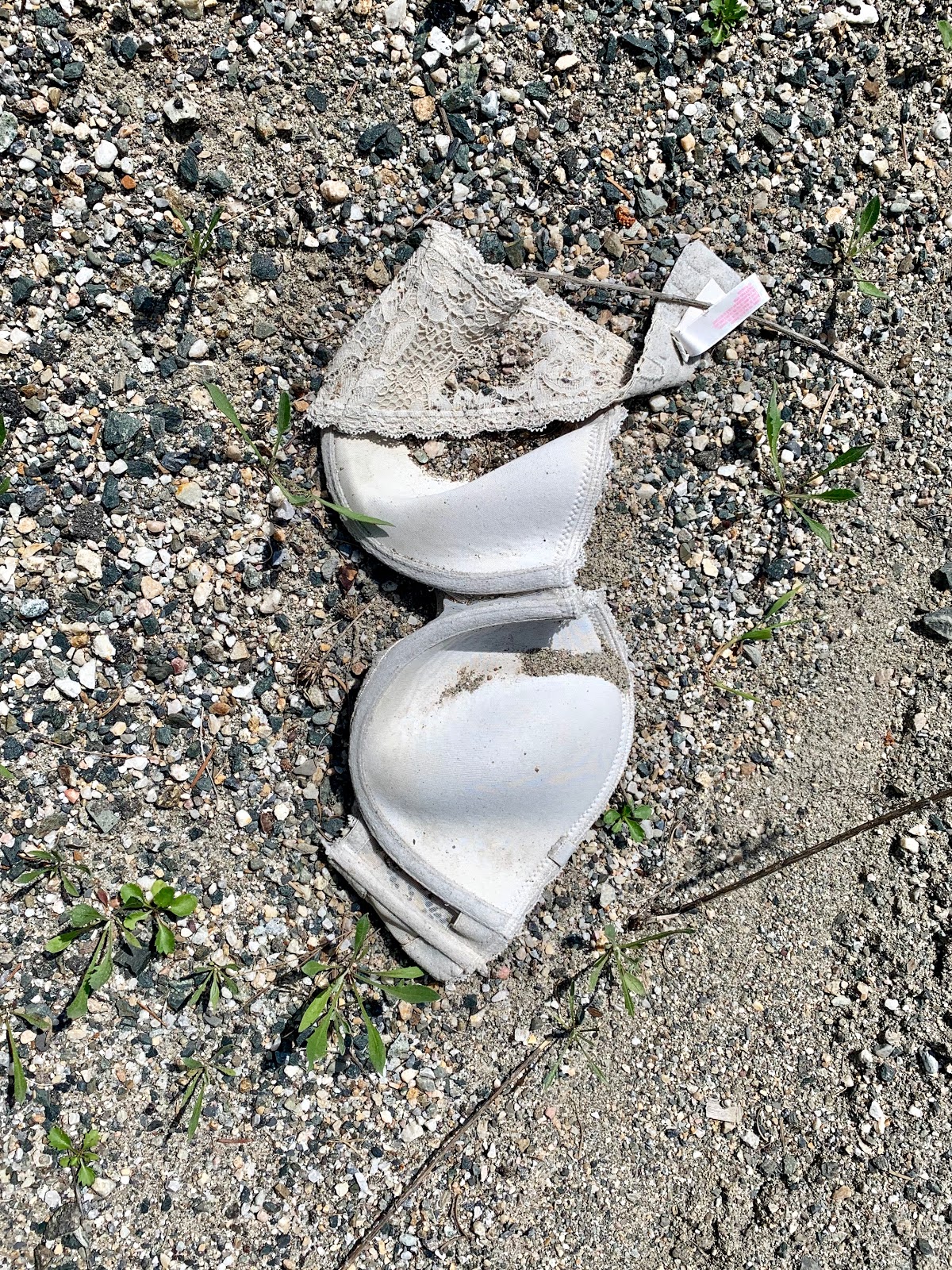
I entered Colville National Forest, and was going every which way on the switchbacks. The wind was still out of the south. I passed what I thought was a pair of skulls but it turned out to be a white brassiere. I noticed several nearby beer cans and bottles. Was it teenagers or grownups? It’s a shame how much litter I pass. I was on Washington State Bike Route 10.
I passed a sign for the Tiger Meadows Demonstration. 284 acres of meadow were permitted here for summer grazing. Up on the ridge I passed Frater lake. I entered Stevens County and then began a downhill. I passed a decomposing recent roadkill deer. It had gone into rigor mortis and it’s jawbones had torn through the skin.
I rode by Thomas Lake to the left and from there began the Little Pend Oreille River. I was now heading south, and had a headwind. What should have been a fast cruise was hard work. I saw a northbound cyclist, ostensibly a day cyclist, wearing a backpack.
I had a 40 inch shoulder down to gravel and hardly any traffic. An asshole in a sporty red car honked and I instantly threw up my finger. I hope he rams his car into a telephone pole. I’ve had no cell phone service all day, yet at one moment a stream of texts and emails came in.
I stopped at Crystal Falls to made an audio recording and take a photo. I came down the west side of the ridge, and had a nice phone call with my mom. I took a left on Artman Gibson Road to take me off of Highway 20. I was 10 miles from my destination. I stopped to take a photo of a mountain range behind a lake and realized there was a large system in back of me to the north. Hopefully it wasn’t headed south, because I was planning to camp tonight.
There was a hostel outside of Coleville that Transgang Brian had mentioned, but it was 7 miles out of town. I wanted to be near some liquid refreshment. I didn’t want to sleep at the hostel, but the idea of a shower and shave was enticing, so I stopped to return myself to cleanliness level one. I signed the guestbook and met the owner on my way out. She thought it was odd that I wasn’t staying there. Food and beverage was 40 minutes away, and I preferred to sleep outside. The Stevens County Fairgrounds Campground sounded much more appealing.
In the shower I became aware of a sore spot between my legs that had been rubbing up against my saddle. I had gotten away from the morning chamois butter routine. I have all these half empty tubes at home and didn’t want an additional one, so I packed a halfy. My current tube is almost dry. There’s also a nasty sore on my right ankle where I always bang my pedal when I’m trying to stabilize my bike taking a photo or changing my clothing. It’s getting worse and not better.
I passed a wild turkey hen and a bunch of chicks during a pleasant downhill into Colville, population 4,673, and my destinations for the day. I’ve been seeing espresso stands, which is a Pacific Northwest phenomenon that I remember from last year. In Colville I thought that it might be a good idea to locate and scout the campground before I went to the bar, so that I didn’t end up in a situation like last night.
Afterwards I rode over to Fired Up Brewing where I ordered the Whiskey Barrel Ale, the Huckleberry Pucker, and the Spruced Up Red Ale. I got two pulled-pork sandwiches along with salads. I told the bartender about the Montana three pint rule and they don’t have that shite here. Unfortunately though, they closed at 7pm. I then went to South Main Sports Bar and ordered a Mac & Jacks from Redmond, WA while I finished this report.


Comments
Post a Comment