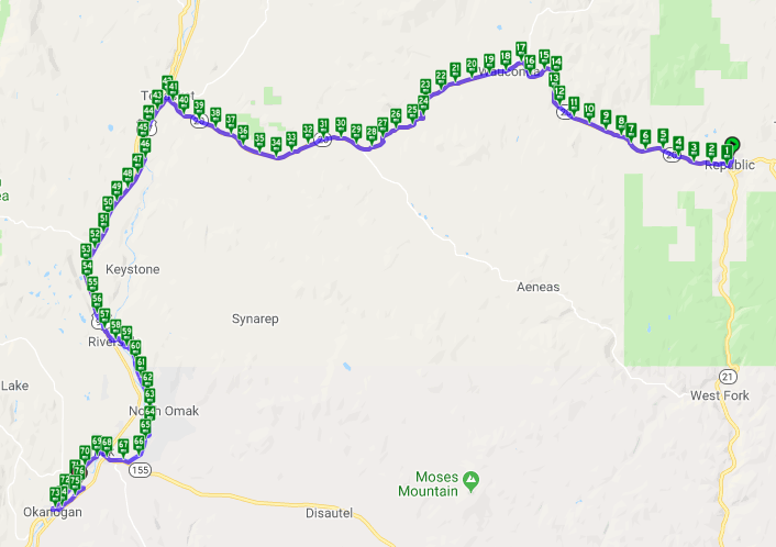
Northern Tier Day #57 Republic, WA to Okanogan, WA
Northern Tier Day #57
July 16, 2019 Republic, WA to Okanogan, WA 76 Miles
Ride Time 5:40
Tour Total 4457 Miles
I slept like a rock at my Warm Showers hosts Rob and Patty’s house last night in Republic. Last night Patty cooked amazing pasta with homemade pesto, veggies, and salad. For dessert we had huckleberry compote with ice cream. My hosts were both pharmacists. Rob runs the Republic Drug Store and Patty works at the hospital. I enjoyed our conversation last night on their back deck that overlooked breathtaking vistas. Today was Rob‘s birthday, and Patty baked him a huckleberry pie. My friend Brian, from last year’s Trans Am crossing, stayed with Patty and Rob, and enjoyed seeing a photo of us together.
Rob gave me a small container of frozen huckleberries for the road. All of my laundry was washed and dried. My tent had been hung out to dry. I was showered and shaved, and my devices were fully charged. I woke up early and left before Rob and Patty were up, and rolled into town to look for breakfast. I spotted 4 touring bikes in front of the Knotty Pine Restaurant, and it was Team Spokane! I went in and joined them. I had eggs over easy, bacon, toast, and orange juice. They had taken a shortcut from Cusick to Republic through Chewelah, and had crossed Sherman Pass yesterday directly after me. The flag man had commented about my no-gap completism. Team Spokane accepted a ride in the back of the pilot car.
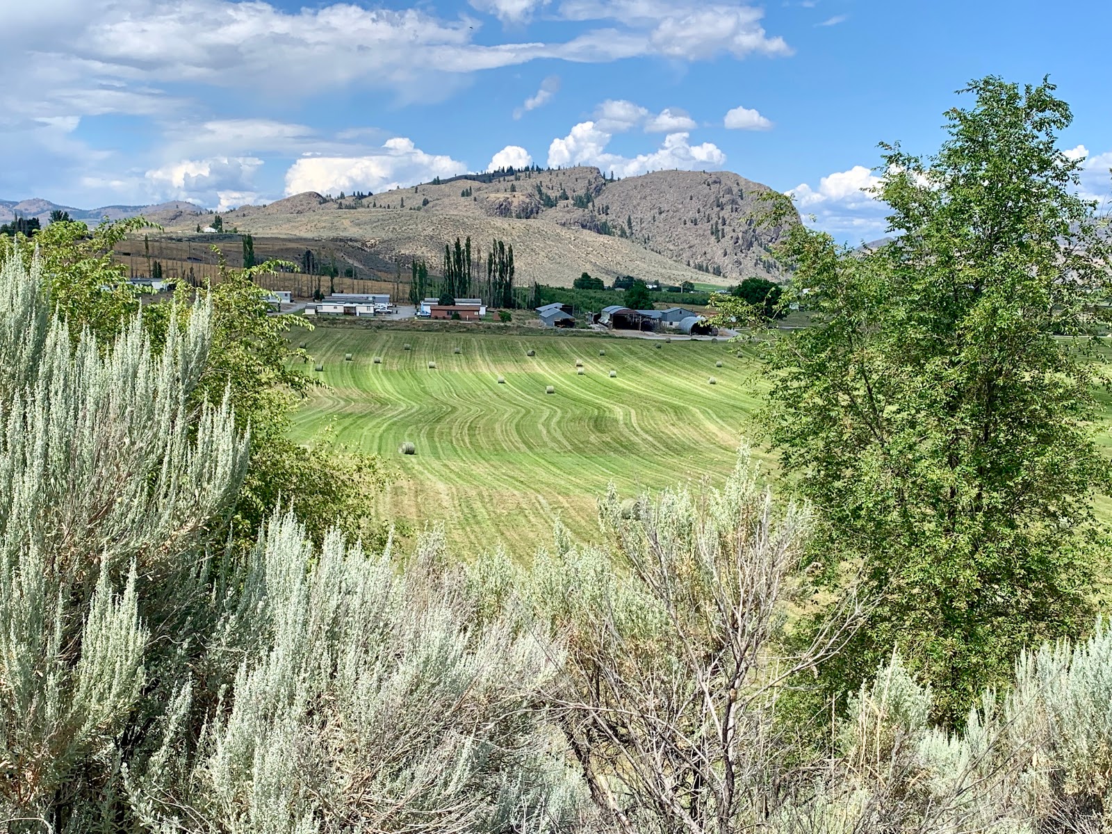
The climb over Wauconda Pass began almost immediately. It was a 2162’ climb over 19 miles. Yesterday Chris, Brian, and I had been describing the climb over Sherman Pass in Williamsburg Bridge units. I entered the Okanogan National Forest, and there was no cell phone service again today. I spotted an eagle with a white tail in the sky to the left. The trees opened up to a nice pasture on the right with a large rock outcrop. There was a small farmhouse and barn up against the ridge. A cow was in the middle of the road and Linda momentarily mistook it for moose. I slammed on my brakes in eager anticipation.
I passed an information sign about old Wauconda, a gold mining town that was once located here. Near to the top of the pass I saw a series of signs. ‘Road Work Ahead’. ‘Be Prepared to Stop.’ The third sign was knocked down, and I wasn’t sure how to interpret that. Team Spokane and I documented the top of the pass, and I shared my frozen huckleberries. I donned a jacket for the bracing decent. The downhill began on fresh asphalt.
I passed a large open pasture and the remains of a 150 year-old house, started by a German immigrant and was never finished. It was still standing but in severe decline. Tim is a carpenter, and was considering a rehabilitation.
Puffy clouds were to the north and storm clouds were to the south. There were blue skies to the west where I was headed. Team Spokane has a system where they stop every 4 miles on a downhill, in case one of them has had a mechanical failure. I removed my jacket on the second stop.
There was construction and only one lane was open. The flagger let us through. The valley opened up wide with sage brush to the right and a cattle grazing pasture to the left. A semi-truck honked at me and I instantly gave him the finger. I hope he crashes into a telephone pole.
The local sheriff went speeding by with his lights and siren blaring. I realized that I hadn’t heard a siren since I left Brooklyn. It was a wide open expanse with sage brush as far as my eye could see, with craggy rocks up on the ridges. The downhill continued down into the valley passing rock cuts and scrub. The area between the Rockies and the Cascade Range was dry, and there were very few trees.
We got caught in traffic coming into Tonasket, population 1,032. There was a steep hill and trucks had to go slow. We decided to wait for the motorized traffic to pass before riding down into town. I stopped at Junction to buy a Gatorade. From there I rode to the Tonasket Natural Market where I ordered a basil & cheese panini with a ginger ale. We all sat out back at a picnic table.
According to the route, we were supposed to leave Tonasket via Highway 7S. I followed Tim as we remained on State Highway 20, aka Bicycle Route 10. I was heading down the Okanogan River valley with bare scrub in every direction, except for a fruit orchard to the right. I had a 5 foot wide shoulder with rumble strips and a white line to the left. Gravel and the ditch were to my right. I was surrounded by bare desert, and was on the Okanogan Trail. Train tracks were to my immediate right, and I had a strong headwind.
This area is heavily irrigated, and there were fruit orchards to both sides of the road. I crossed over the brown-colored Okanogan River. The further away from the Continental Divide the muddier the water got. I eventually converged back with the route. State Highway 20 had motorized traffic.
I was technically on both State Highway 97 South and State Highway 20 West, and I was traveling south for several miles. I spotted a red piece of string that paralleled the shoulder for miles. I believe it was for fiber optic cable installation. There was scrub in every direction with the occasional pine tree. Sage brush was everywhere.
Tim was way out ahead, I was a distant second, and the rest of the pack was right behind me. Jeff drafted me for a while and then passed me. Tim stopped at a turn-off and Jeff flew right by him. The four of us turned off of Highway 20 to take Omak Riverside Eastside Road to Omak. I texted Jeff to meet us in town. We crossed over to the east side of the river where there was less traffic.
We stopped to help a motorist whose vehicle lost its reverse gear. Her car was wedged up against a trailer. Tim, Henry, and I pushed it back to where she could go forward. There was a pear orchard across the street. Tim was convinced that we had just aided and abetted a meth dealer, and that federal agents would soon be on our tail.
I entered the Colville Indian Reservation. After a little pedal I came to Omak, population 4,845. Omak had an elevation of only 850 feet. I passed a large arena home to the Omak Stampede. A jet flew overhead and I realized that I hadn’t heard a jet plane since Bismark.
Jeff texted that he was waiting for us at Safeway. We pulled into town and stayed on route, assuming we would meet up with him. We soon realized we were on the edge of town, and stopped at the Sunrise Chevrolet to wait for Jeff to meet us. He had been enjoying himself, eating bear claws and drinking ice-cold soda. The car dealership had tepid water and stale popcorn.
Three miles down the road I entered Okanogan, Bulldog Country. I rode past the old Okanogan County Historical Museum and the American Legion Park. On a hill above town was a giant ‘OK’ made from white painted rocks.
Team Brooklyn/Spokane cycled to the Okanogan IGA to pick up provisions for the evening feast. They had arranged a Warm Showers host for the evening that I had contacted during breakfast. She told me that I was welcome to spend the night as well. I crossed the river and returned 2 miles north to our Warm Showers host. I was carrying three 6-packs of beer.
We arrived before our host Leone, and made ourselves at home on her lovely back porch. When Leone arrived, she convinced us to take a refreshing float down the Okanogan River before dinner. Afterwards we grilled burgers and Leone made incredible potatoes and salad.


Comments
Post a Comment